Budapest Time Machine
Introduction
Time Machine enables not just retrieving historical data but also offers navigating in space and time via interactive maps, with quick and simple crossing through different time sections. We can study the transformation of the city, search for old locations and gain access to archival sources related to the history and inhabitants of the individual plots and houses. Time Machine is supported by the huge database of Hungaricana Cultural Heritage Portal which contains millions of pages of digitalized source-material about the residents and buildings of the city, providing large amount of datas related to exact places and dates. Our aim is – with gradual development – to make all these available in an easy, quick and entertaining way with the help of historical maps. Now, as a first step, you can find the following sources with the help of the Time Machine:
- Land registry files from the end of the 19th and the beginning of the 20th century (predecessors of the recent proprietorship registers), which provide not only the registration of changes of the owners, but also large amount of data useful for family, society and economic history from the period of Budapest turning into a metropolis
- Building plans from the same period, photos and postcards
The Time Machine is ideal for deep research as well as relaxation.
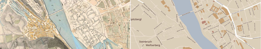
In the Budapest Time Machine / Maps application there are four different time sections (1837, 1873, 1908, 1937) in which the transformation of the city's structure can be studied by the assistance of vectorized maps made by the contemporary available most detailed high resolution maps. On the maps of different ages you can search simultaneously for all the names (streets, squares, quarters, buildings, etc.) from different ages occurring on the maps. The results are signed by red indication on the map, clicking on the list, the view of the map jumps on the proper object.
In the Budapest Time Machine / Documents application we can reach to the sources related to the individual real estates. On the map if you click on the lot number – which is signed on the land – the historical topographical description of the land opens (if included in the Topography database) and photos related to the area appear, as well as links to archival sources. Using the setting options available under the Historical maps inscription, we can change easily the map of today's street map (OpenStreetMap) or any georeferenced historical map as a base map, but we can also choose the vectorized version of these, known from the Budapest Time Machine / Map section. By setting the "slider", we can make the old map „transparent”, so that we can compare it with the today's state.
From the page of the Time Machine aerial photographs - made of Budapest in 1944 - are also available. In April 1944, the Hungarian Royal Air Force, after a few days of the first major bombings by the Allied forces, made photographs of the bombed districts of Budapest from low altitudes. The negatives of roughly 550 aerial photographs have been researchable until recently in the Military History Archives. These materials have become available thanks to the efforts of Arcanum and Fortepan with precision assembling, cutting of excesses, reduction of deformations and georeferencing.
For the time being, the GIS (geographic information system) database for the victims of the Hungarian Revolution of 1956 can be used in separate application, which displays - on the map in a searchable way - people who lost their lives most likely in the revolution from 23 October 1956 to spring of 1957.